“Statswork handled our face-to-face survey project professionally and delivered highly accurate field research data within the timeline.”
Healthcare Researcher
Data Analysis services
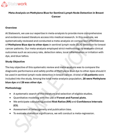
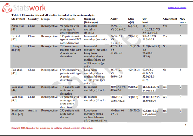
Meta-Analysis Research Services
Data Collection Services
Statistical Programming & Biostatistics services
Data Management Services
Research methodology services
Tool development services
Statistical Interpretation services
Sample Size Calculation Services
Artificial Intelligence and Machine Learning Services
Report generation Services
Data Analysis services
Meta-Analysis Research Services
Data Collection Services
Statistical Programming & Biostatistics services
Data Management Services
Research methodology services
Tool development services
Statistical Interpretation services
Sample Size Calculation Services
Artificial Intelligence and Machine Learning Services
Report generation Services


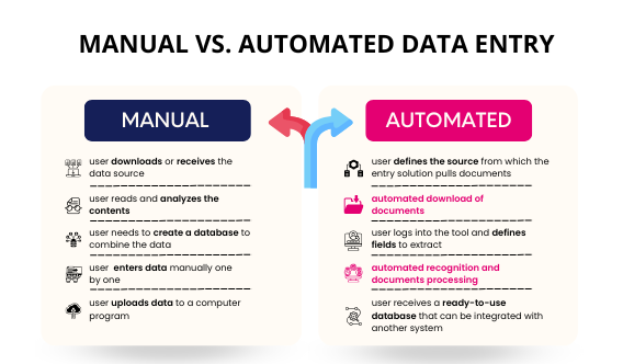
Face-to-Face Data Collection Services assist in gathering reliable information through direct respondent interaction and offline surveys. The services offered by professional providers include Face-to-Face Data Collection Method, Face to Face Interview Survey, field interviews, and in-person research activities depending on the project requirements. An effective Face-to-Face Data Collection and Management ensure accurate response collection and proper organization of research data. The custom services are provided to assist industries in healthcare, education, marketing, finance, retail, and business research.
Steps Involved in Effective Face-to-Face Data Collection ServicesThe steps involved in providing Face-to-Face Data Collection Services effectively include:
Face-to-Face Data Collection Services are employed by researchers, organizations, and companies to collect genuine and accurate information from the respondents through their direct interaction. Proper collection of field data leads to the formation of well-structured data sets which contribute to research quality, business planning, and strategic decision making.
The situations under which Face-to-Face Data Collection Services can be applied include, but are not limited to, the following:
Our professional Face-to-Face Data Collection Services will assist you to structure field responses into research data sets.


Healthcare Researcher

Market Research Manager

Business Analyst

University Research Coordinator